Monday, December 12, 2005

Water Canyon (Dec 2005)

Water Canyon should actually be apart of Zion National Park, but it lies in Arizona next to the polygamist town of Hilldale. The hike I did follows the stream up into this narrow subway type section, then continues on for a total of about 4 miles up 2000' to the top of a slickrock paradise.


The cold winter day I went featured long frozen icicles in the subway section.


See the small stone at the bottom for scale of these wavy colorful ribbons of slickrock.

Saturday, November 12, 2005

South Canyon in Grand Canyon (Nov 2005)

Me hiking down into South Canyon, a side canyon of Marble Canyon in the GC. The hike is about 7 or 8 miles one way, and drops several thousand feet. I spent one night down there during a warm spell in November. Notice in the distance Vasey's Paradise spilling out into the river.


This is a shot from below of Vasey's Paradise. It is basically a huge spring that shoots out of the Redwall layer. There was a lot of poison ivy in this area. There is also a huge cave that nearby that has stick figures dating back several thousand years.


Sunday, November 06, 2005

West Rim Trail in Zion (Nov 2005)


For my 40th birthday, Kim and I went and stayed at the Zion Lodge, and did some hiking. Here we are enjoying the Fall colors on the trail up to Angels Landing.


Here I am standing in front of one of the stunning views of the West Rim.


Here's Kim on the slickrock trail leading down off the rim.

Monday, October 10, 2005

North Rim Grand Canyon wanderings about (Fall 2005)

I spent a couple of different trips out at the North Rim of the Grand Canyon with the family to enjoy the fall colors, and another trip with my friend Mike Burkley to do a backpack trip down to Cottonwood Campground and Ribbon Falls. Here are some of the best photos:


Fall colors along the North Kaibab Trail


Ribbon Falls, falling approximately 90 feet.


Me behind Ribbon Falls.


Sasha admiring red fall colors while hiking up the North Kaibab trail.


Brooke doing a little free solo rock climbing out on Camp Final Point.


Sasha posing at the top of the North Rim.

Monday, October 03, 2005

Snow Canyon secret petroglyphs (Fall 2005)


Not far from our home, these Anasazi petroglyphs are viewable only by climbing up a steep cliff to access a ledge. They are some of the most unusual petroglyphs around.


Hands or clans connected with energy or lightning?

Sunday, October 02, 2005

Sublime Point looking South (Oct 2005)

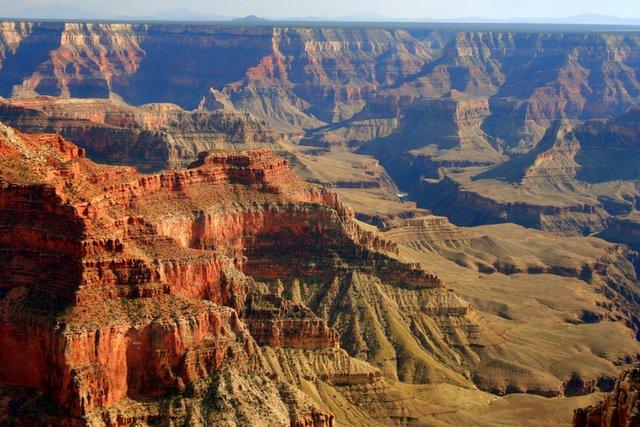
The 17 miles of dirt road along the North Rim to Sublime Pt is quite an adventure, and should not be attempted if the road is wet. But the views are great when you get there. I road my motorcycle out and camped at the point for one night.

Here is the view looking south in the afternoon from Sublime Point at the North Rim of the Grand Canyon. Notice Boucher Rapids.


Sunrise at Sublime Pt.


Blue sunrise!


Rainbow over the canyon!

The Subway in Zion (Oct 2005)


In October 2005, I hiked with my hiking buddy, Mike Burkley, 4.5 miles up the Left Fork or North Fork of the Virgin River, aka. 'The Subway'. This is a fun hike any time of the year, but is especially neat with the fall colors. It has dinosaur tracks, cascades, waterfalls, slots, swimming holes (great in the summer), slickrock, forests, plunge pools, and the famous subway-shaped tunnel slot.


Here we are posing next to an incredible series of cascades that runs the length of a football field.


Mike next to some leaves and a cascading waterfall.


The lower end of the 'Subway'.


Cascading plunge pools and forest above the slot canyon.

Boomer Hill (Fall 2005)


South of Santa Clara several miles there is a round mesa called Boomer Hill that rises 500' above the desert. Kim and I hiked out there and scrambled up the steep upper portion. We continued out to the southwest point, where there were these crazy plank-like rocks sticking over the edge. Kim practiced some yoga poses on the edge here.

Saturday, October 01, 2005

Fall Colors of 2005

Here are some shots of the color and the family in the mountains around Cedar City during the fall of 2005.


Thursday, September 15, 2005

Living on the Edge rock climbing (Sep 2005)


Another favorites of mine is rock climbing in the area. This climb is known as "Living on the Edge" (5.10a), and that's me in the bright yellow shirt.


My belayer is Paul, at the top, a friend from the spa.

Monday, September 12, 2005

Ashdown Gorge Wilderness (Sep 2005)

This deep canyon is located up from Cedar City. It is similar to hiking up the Narrows, in that you must cross the river many times. There are some deep, forested areas, and the water is chilly, since it is coming down from 10,000'+. The hike was 4 or 5 miles up, then I returned the same way.


Friday, September 09, 2005

Zion's Right Fork backpack trip (Sep 2005)

Mike Burkley and I tried this long and difficult backpack trip in September for two days and one night. It requires tricky navigation through thick brush, slickrock, canyons. We descended down a steep ramp to a chockstone where we rappelled not once, but twice. The second rappel was into a pool of ice cold, shaded water. We proceeded down canyon all day and finally arrived at the Grand Alcove, where we camped under a huge overhang of sandstone. The next day we rappelled down Barrier Falls. Just below that was Double Falls (shown below), which I have dayhiked up from the bottom to several different times. It is definitely one of the most challenging backpack trips I have done, but it is also the most diverse and incredibly beautiful.


Mike taking a break near a summit.


Me behind Double Falls.


Thursday, September 08, 2005

Top of the Red Mountain (Sep 2005)

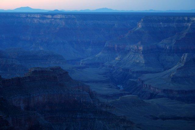
These are views from on top of the Red Mountain while looking down into Snow Canyon above the Three Ponds Trail area. Lots of beautiful slickrock to gaze upon.


Monday, August 15, 2005

Timp Point in the Grand Canyon (Aug 2005)

I spent a day and a night mountain biking on the Rainbow Rim trail along the rim of the Grand Canyon. This was the sunset view from my car camp site.

Monday, August 08, 2005

Kolob Arch and Beartrap Canyon (Aug 2005)

In late summer of 2005, I backpacked one night down in LaVerkin Creek, which is a part of Zion National Park in the Kolob Fingers section. I dayhiked up to Kolob Arch, the largest natural arch in the world. I also dayhiked up into Beartrap Canyon.


A beautiful waterfall blocks further upstream access in Beartrap Canyon. I'm standing in quicksand.


Kolob Arch, as seen from 1/3 a mile away.

Monday, August 01, 2005

Grapevine in Zion (Aug 2005)

A hike down into the Right Fork area and up past Grapevine is a nice little hike in the summer. We actually heard and saw a rattlesnake next to the creek too.


Sasha found a fun way to stay cool on the hike.


Thursday, July 07, 2005

Zion Narrows (July 2005)

One of my all-time favorite hikes is to hike up the Zion Narrows on a hot summer day. I love the coolness, the water, the colors, the canyon, and the photographic opportunities. The combination of blues, grays, yellows, greens, and reds makes for an astounding, magical day.


This is up Orderville Canyon, a side canyon in the Narrows. Notice the hanging gardens and all the colors.


Silky smooth water cascading down through the Narrows.


A lone backpacker heading downstream.


A house sized boulder diverts the water into a narrow passageway.

Wednesday, May 25, 2005

Nankoweap Day Hike (May 2005)

The first day the North Rim Grand Canyon road was opened, I drove out and spent the night at the top of the Nankoweap Trail. The next morning I dayhiked down to Marion Seber Pt and back (about 10 miles roundtrip).


Beautiful sunrise through a ponderosa.


View from along the Nankoweap Trail.


The 'scary' ledge part of the trail.


A 'lake' just inside the park boundaries. Due to the wet winter, the road opened a week late.
 
!-- Site Meter XHTML Strict 1.0 -->