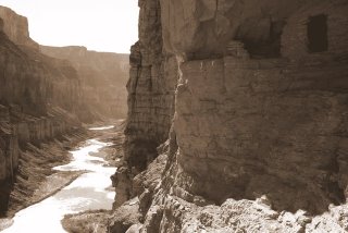

I decided to try this difficult hike at the spur of the moment when I heard that Kim's friend was coming to town for President's Weekend to go see the Parade of Homes. I went to the BLM to secure the permit from GC for three nights. The guy on the phone from the backcountry office wanted me to fill out a hiker information sheet giving my shoe type and size, etc. The BLM didn't have this sheet, so they just let me go, as is, and as a solo hiker. My itinerary was to hike down Nankoweap one night, go over to Kwagunt one night, then back to Nankoweap for the last night.
Friday morning I got up at 4AM and drove to the trailhead. The weather forecast showed a snow storm moving in on the last night, so I was considering shortening my trip to two nights. In the truck halfway there I realized that I had forgotten my first night's meal of chicken strips back home in the freezer. That was the deciding factor for me to just go 3 days and 2 nights. Fortunately, the road across House Rock Valley was dry and in good shape.
I got on the trail at 7:45 and started the 3 mile climb to Saddle Mountain, which is about 1000' in elevation gain. There was hardly any snow, just a few inches in patches, so the hike up the saddle was not difficult. An hour and a half later, after topping out I enjoyed the views, then started the 4 mile traverse through the Supai layer. This is a tedious part of the hike which requires full concentration. There are many boulders and shrubs and trees to go around, up and over. And there are many narrow ledges which are not difficult, but do require full concentration and slower steps. At one point the ledge narrows to six inches with a steep slope down about 10 feet before the cliff goes sheer down a thousand feet or more. Many hikers are intimidated at this point, but I didn't find it too difficult, even with a pack, because there are some nice flat ledges at waist high used for palming and mantling across this section.
After 2.5 hours of the Supai, I finally got on top of the Redwall on the Tilted Mesa ridgeline and enjoyed a quick lunch. The spectacular view here was in 300 degrees. I could see the river down to the east through Little Nankoweap Creek drainage. However, I was going to go down the west side of ridge towards the Nankoweap Creek drainage. This part of the trail was extremely steep--much like going down the gunsight trail off of Red Mountain. The loose rock made the going very slow and tedious, especially with a pack. On down through the redwall, switching back and forth, then doing the same through the Muav layer, then traversing a long ways in the Bright Angel shale--this is how it was going to be. There were a number of narrow sections of the trail here too, but without any handholds. The shale was small and compacted, so fortunately my footing did not slip. The important thing was to focus, take careful steps, and keep moving with balance and to watch the pack for shifts or bumps from obstructions.
Finally, after dropping 3,000' in 3 miles and 2 hours later I arrived at Nankoweap Creek, the first water in 10.5 miles. I took my boots off, put my feet in the creek, and relaxed under a nice cottonwood (no leaves on it yet) at a camp sight. I was debating on staying here the night, but I really wanted to get to the Colorado River. I had met one solo hiker in the middle of the Redwall as he was hiking out. He drove a compact Chevy to the trailhead, and had hiked down the previous night all the way to the river. Now he was on his way out--a very quick trip. He said that he was disappointed that Nankoweap Creek dried up down by the Colorado River, and he was unable to see or catch the trout run up it. It was only 1:45, and so I had plenty of time to meander the 3.5 miles down to the river. I finally got to the river about 8 hours after I left the truck.
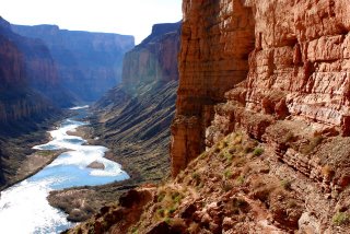
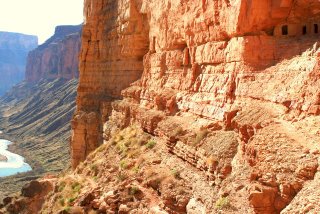
Sure enough, about 200 yards from the Colorado, Nankoweap Creek dries up. I turned right and hiked up a small hill that had some ancient walls of ruins intact. I looked across the delta and admired the view. I think this is the best view of the river in the canyon. There was a boat party camped down river a half mile to the right. I decided to walk straight ahead and camp at the foot of the main rapids on a nice sandy beach. That night I enjoyed a freeze dried rice and chicken dinner. The sound of the rapids is so soothing. It was easy for me to go to sleep by 7:30. I listened to half of 'Call of the Wild' on my Ipod.
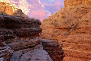
The next morning after oatmeal, I hiked up 500' on the cliff above camp to the small granaries. This is where the river view is exceptional, as you can see nearly 8 miles of river through a beautiful, narrow marble canyon. Some of the boaters hiked up while I was coming down, and offered me to come to dinner. They were laying over for two nights to do some relaxing and exploring. I decided to dayhike and explore up Little Nankoweap drainage. It has some neat narrows with a little bouldering up and down.
I came back down and got my pack and said goodbye to the river, as I hiked up the creek 3.5 miles to the cottonwood tree camp spot. After setting up camp I continued up the creek another mile or so to check out the creek and the broad valley. There was a swimming hole that invited me in. The air temp was 70, and the water temp was not terribly cold, so I dunked myself and cooled off. On the way back to camp I looked for the horse thief trail that went up the south toward Nankoweap Butte. The trail continues over to Kwagunt and then on down to Lava/Chuar Valley. This is where horse thieves would take their stolen horses down Nankoweap, cross the Colorado, and ride up Tanner Trail on the south side of the canyon to escape posses.
That night after finishing a Chile Mac dinner, the temps were in the mid 40s, maybe a little bit warmer than when camping by the river. I finished 'Call of the Wild' and listened to a few tunes. Next morning after oatmeal I hit the trail by 7:30. It was slightly overcast, which helped keep the hot sun away. It was very long and strenuous, but I made it back to the truck 6.5 hours later. This is a very difficult hike, probably the most difficult one I have endeavored with a backpack. Some people say that North Bass is the most difficult, but I think Nankoweap is slightly more difficult. I did the North Bass a few months ago so it's fresh on my mind. If Nankoweap is a 10, then North Bass is a 9, on a scale of difficulty. These are the reasons why I think Nankoweap is more difficult:
1. No water for 10.5 miles
2. The 4 mile Supai traverse is very mentally exhausting
3. The Redwall descent is very loose and steep and mentally challenging. The Redwall in North Bass is steep too, but not as long.
4. Time required--it took me about 45 minutes longer to go the same distance and elevation compared to North Bass. This is most likely due to it being steeper in the Redwall, and more taxing through the Supai.
That being said, would I do it again? Most definitely, after a number of years have passed. I would like to explore Kwagunt and possibly get down to the Little Colorado, get ferried across by a passing boater, and then continue down the Beamer/Tanner trail out to the South Rim. I would also cache water on top of Tilted Mesa. I had only 2 liters with me, and I could have used a third one! Marion Seber seep was bone dry, compared to slowly dripping two years ago when I dayhiked down to check out the 'scary ledge' spot in the Supai.
Elevations:
Saddle Mtn TH: 6800'
Top of the saddle: 7600'
Tilted Mesa ridgeline: 6500'
Nankoweap Creek: 3600'
Colorado River: 2800'
Total Miles: 14 (day 1); 9 (day 2); 10.5 (day 3)
On the way home I drove over to Buck Farm overlook. This was a nice view right there from the road on the rim.
-dNally
View West from Tilted Mesa

View south from Tilted Mesa. Nankoweap Mesa in the background.

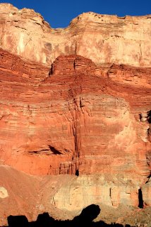
Cliff face from Colorado River and Nankoweap Creek.
Colorado River from Nankoweap Ruins
Ruins in Nankoweap
Narrows in Little Nankoweap Creek.


No comments:
Post a Comment